
India Builds Safer Navigation on 111 National Waterways
India has 111 National Waterways of 20,187 km and moved 218 MMT of cargo in 2025-26, with the first riverine lighthouses coming up on the Brahmaputra.
Why in News
A PIB backgrounder issued on 16 October 2026 described how India is making inland navigation safer and smarter, setting out 111 National Waterways of 20,187 km, cargo of 218 MMT in 2025-26 and the country's first riverine lighthouses on the Brahmaputra.
India is rebuilding its river transport around a simple idea: a vessel should know the river before it sails. A Press Information Bureau backgrounder of 16 October 2026 sets out how river surveys, navigation aids and digital portals now work together on the country's National Waterways, and why safer navigation matters as cargo volumes climb.
The network today
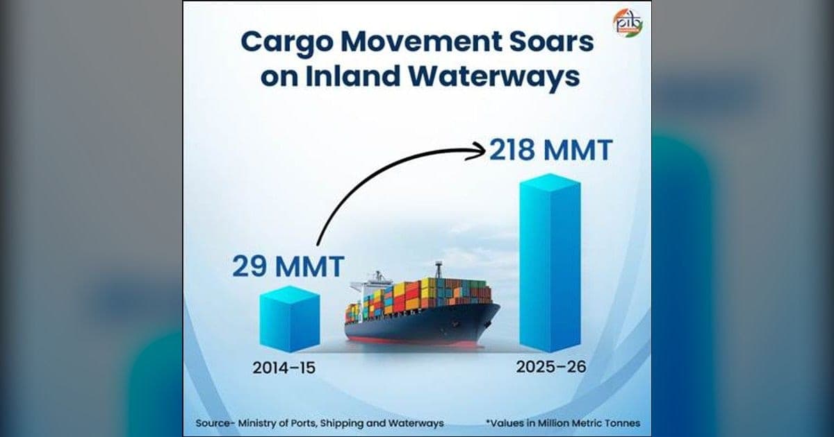
The country counts 111 National Waterways, running to 20,187 km across 23 States and 4 Union Territories. Of these, 32 carry traffic at present. Freight has grown sharply. Cargo moved on inland waterways stood at 29 million metric tonnes (MMT) in 2014-15 and reached 218 MMT in 2025-26, a compound annual growth rate of 20.13 per cent. That already crosses the 200 MMT mark that Maritime India Vision 2030 had set. Carrying a tonne of freight by water costs about a third of road and half of rail, and releases far less carbon, which frees highways for passengers and time-sensitive goods.
Knowing the river
The Inland Waterways Authority of India (IWAI) runs hydrographic surveys that measure depth, bed profile, shoals and flow. Thalweg surveys trace the deepest navigable line along a stretch, while terminal and jetty surveys check approach conditions. By September 2026 regular thalweg surveys covered 22 National Waterways, repeated weekly, fortnightly or monthly as each river demands; the Indian leg of the Indo-Bangladesh Protocol route was covered too. Their key output is the Least Available Depth (LAD), the minimum depth in a channel for a stretch and a season. LAD fixes the draft a vessel may carry, and so its cargo.
Aids to navigation
Buoys, radar beacons (racons), channel markers and lighthouses are recognised as Aids to Navigation under the Marine Aids to Navigation Act, 2021. The Directorate General of Lighthouses and Lightships (DGLL) maintains them along the coast, and India follows IALA guidance besides its SOLAS obligations. National Waterway-3 in Kerala, the West Coast Canal linking Kottapuram and Kollam, carries 312 solar-powered lighted FRP buoys and 17 beacon lamp posts.
First riverine lighthouses
In March 2026 India announced four riverine lighthouses, its first, on the Brahmaputra, which is National Waterway-2. They are coming up at Pandu, Bogibeel, Silghat and Biswanath Ghat at a cost of ₹74 crore. Each will stand 20 metres tall, reach 14 nautical miles geographically and 8 to 10 nautical miles in luminous range, run on solar power and carry weather sensors; museums, amphitheatres and cafeterias are planned alongside. NW-2 covers 891 km from Dhubri to Sadiya in Assam, the longest navigable stretch in the country, serving tea, coal and fertiliser supply chains. Its cargo rose from 0.90 MMT in 2024-25 to 1.29 MMT in 2025-26.
Digital navigation
Electronic Navigational Charts had been prepared for 18 operational and tidal waterways by September 2026, against only NW-1 before 2014, and sit on the PANI portal and the IWAI Vessel Tracker. Naudarshika, the National River Traffic and Navigation System launched in 2025, adds real-time LAD to traffic management. River Information Services run on NW-1 over Haldia-Farakka, Farakka-Patna and Patna-Varanasi with 4 control stations, 13 base stations, AIS equipment and VHF links, and consoles on 30 departmental vessels.
Important Facts
| National Waterways | 111, total length 20,187 km, 32 operational |
|---|---|
| Spread | 23 States and 4 Union Territories |
| Cargo 2025-26 | 218 MMT, up from 29 MMT in 2014-15 (CAGR 20.13 per cent) |
| Target crossed | 200 MMT under Maritime India Vision 2030 |
| First riverine lighthouses | Pandu, Bogibeel, Silghat, Biswanath Ghat on NW-2 (Brahmaputra), ₹74 crore |
| NW-2 | Dhubri to Sadiya in Assam, 891 km, longest navigable stretch in India |
| NW-3 | West Coast Canal, Kerala, with 312 lighted FRP buoys and 17 beacon lamp posts |
| Digital systems | PANI portal, IWAI Vessel Tracker, Naudarshika (2025), River Information Services |
| Authority | Inland Waterways Authority of India, Ministry of Ports, Shipping and Waterways |
Exam Point of View
Fix the numbers: 111 National Waterways, 20,187 km, 32 operational, 23 States and 4 Union Territories; cargo 218 MMT in 2025-26 at 20.13 per cent CAGR against a 200 MMT target under Maritime India Vision 2030. Remember NW-1 is the Ganga system, NW-2 the Brahmaputra (891 km, Dhubri to Sadiya, longest navigable stretch) and NW-3 the West Coast Canal in Kerala, and that the first riverine lighthouses are at Pandu, Bogibeel, Silghat and Biswanath Ghat.
Practice Questions
How many National Waterways does India have at present?
- A.101
- B.106
- C.111
- D.121
Show answer
India has declared 111 National Waterways to promote shipping and navigation, and their combined length comes to 20,187 km spread over 23 States and 4 Union Territories.
Read the full explanation →India's first riverine lighthouses are being set up on which river?
- A.Ganga, National Waterway-1
- B.Brahmaputra, National Waterway-2
- C.West Coast Canal, National Waterway-3
- D.Godavari, National Waterway-4
Show answer
Four riverine lighthouses, the first of their kind on an inland waterway in India, are being built at Pandu, Bogibeel, Silghat and Biswanath Ghat under a ₹74 crore project announced in March 2026.
Read the full explanation →How much cargo moved on India's inland waterways in 2025-26?
- A.118 MMT
- B.168 MMT
- C.218 MMT
- D.318 MMT
Show answer
Cargo movement on inland waterways stood at 29 million metric tonnes in 2014-15 and climbed to 218 MMT in 2025-26, which works out to a compound annual growth rate of 20.13 per cent.
Read the full explanation →Frequently Asked Questions
How many National Waterways does India have and how long are they?
India has 111 National Waterways with a combined length of 20,187 km, spread over 23 States and 4 Union Territories; 32 of them are operational at present.
Where are India's first riverine lighthouses being built?
On the Brahmaputra, which is National Waterway-2, at Pandu, Bogibeel, Silghat and Biswanath Ghat. The ₹74 crore project was announced in March 2026 and each lighthouse will be 20 metres tall with a geographical range of 14 nautical miles.
What is Least Available Depth?
It is the minimum depth of water in a navigation channel, assessed for a given stretch and period. It decides the permissible draft of a vessel and therefore how much cargo it can carry, and it guides route scheduling.
Sources
- भारत के जलमार्गों का विकास: एक सुरक्षित और बेहतर जलमार्ग नेटवर्क का निर्माण (opens in a new tab) — Press Information Bureau
Current Affairs 16 October 2026
- APEDA Flags Off Maiden Palmyra Jaggery Export to BulgariaEconomy
- Polish Youth Delegation Ends Jamsaheb Memorial Exchange in IndiaInternational
Related Current Affairs

Related GK
- Population and Tribes of MP: Bhil, Gond and Baiga
16 October 2026 · Madhya Pradesh
- Industries of Madhya Pradesh: Pithampur, Cement and Mills
16 October 2026 · Madhya Pradesh
- Industries and Minerals of Haryana: Towns and Products
16 October 2026 · Haryana